The application of digital electronic maps, which are used in the process of survey work, is also considered, brief guidelines for creating these maps in the ArcGIS program are also given, the main advantages of digital technologies are indicated.
Keywords: soil surveys, soil survey, ArcGIS, soil map, digital electronic map, attribute data, soil layer, contour vectorization, map layout.
Joining the thirty most advanced countries of the world is a task set by the President of the Republic of Kazakhstan for Kazakhstani citizens. Such a global breakthrough of the country is impossible without improving the industries where the most advanced achievements of science and technology are used.
Kazakhstan occupies the ninth place in the world by area. The length of its land borders is 13393 kilometres. Despite these indicators, Kazakhstan is a sparsely populated country. With such vast territories, it is necessary to monitor land resources and control them using advanced methods of controlling land resources.
Currently, the country's land resources are in critical condition, there is widespread desertification of pastures and depletion of arable land. The main causes of desertification of land resources are soil erosion, salinization and waterlogging of areas covered with sand, which as a result leads to a deterioration in yield and soil fertility.
One of the main issues at the state level today is the preservation of land resources in a natural state, from which the results of its functioning follow. To date, a number of projects and programs are being implemented to ensure the protection and control of the country's lands by the state, and their amount of funding is growing annually.
According to the Law of the Republic of Kazakhstan «On Informatization», the most important goal of state policy is the formation and development of the world level of information technology development, as well as information support for the social and economic development of the country.
To increase the level of resource supply, by increasing the availability of information on land resources, the Ministry of Agriculture of Kazakhstan implements the program «Increasing the availability of information on land resources». The program is aimed at forming information of the state land cadastre, creating geodetic and cartographic products, providing various sectors of the economy with cadastral information.
In order to increase the rational use of land, strengthen the responsibility of tenants, regulate the provision of agricultural land, a documentary audit of all categories of land and the quality condition of agricultural land is carried out. This type of work relates to soil surveys. In particular, the soil survey is considered as the most effective method of identifying degraded lands.
The purpose of the surveys is to identify degraded and polluted lands with the establishment of the degree of their degradation, including eroded lands, flooded lands, wetlands, lands polluted as a result of human economic activity and other lands subject to negative impacts.
The soil survey provides:
– soil zoning, that is, the division of the territory according to the nature of the soil cover;
– soil-reclamation zoning, that is, the division of the territory according to natural and irrigation-economic conditions;
– compilation of a soil erosion map showing the distribution of soil taking into account the degree of land erosion;
– conducting soil surveys.
In the course of soil surveys and surveys, a soil map is formed that displays the placement of soils, as well as the mechanical composition of soils and soil-forming rocks. Depending on the specific conditions, in addition to the soil map, special maps of soil erosion, saline soils, excessively moist soils can be compiled.
Currently, the use of powerful software for the compilation and updating of soil maps, specialized geoinformation systems designed to solve the problems of territory management is practiced. More and more specialists are moving to a new paperless level of data acquisition and interpretation based on electronic presentation of information.
The developed soil electronic maps will expand the level of informativeness. The main advantages of these cards are: visibility, convenience, efficiency, accuracy, ability to make changes in real time, quick access to any data block, compatibility with computer software and management programs.
The creation of an electronic soil map consists of three main stages:
– preparatory (selection of soil materials and information processing);
– main (vectorization of soil contours and entering data into attribute tables);
– final (layout and printing of the map).
The preparatory stage includes: selection of soil materials and information processing, determination of the coordinate system of the created map, translation of the original cartographic materials from paper to electronic format. The translation from paper to electronic format is carried out by scanning the author's cards and used photo tablets. When scanning the material, a resolution of 200–300 dots per inch should be set.
The next step of the preparatory stage is the creation of the author's personal database. The personal database consists of a soil layer of the map (Figure 1) and a table of attribute data (Figure 2). Upon completion of the creation of the author's personal database, raster materials, the author's soil map and photo tablets are linked to the coordinate system of the personal database.
Table 1
The soil layer of the map
|
NAME |
Nickname |
TYPE |
SIZE |
|
OBJECTID |
Счетчик |
Object ID |
Авто |
|
Shape |
Поле объекта OLE |
Geometry |
Авто |
|
ID |
Идентификационный номер |
Long Integer |
Авто |
|
MEHSOST |
Механический состав почвенного контура |
Short Integer |
Авто |
|
KAMEN |
Защебненность почв |
Short Integer |
Авто |
|
KAMENNN |
Каменистость почв |
Short Integer |
Авто |
|
BALL_B |
Балл бонитета |
Text |
Авто |
|
SHIFRFULLMAP |
Шифр почв, почвенный комплекс |
Text |
Авто |
|
God_Rabot |
Год работ |
Short Integer |
Авто |
|
SHAPE_Length |
Периметр |
Double |
Авто |
|
SHAPE_Area |
Площадь |
Double |
Авто |
Table 2
Attribute data table
|
OBJECTID |
ID |
PROCENT |
STEPEN |
SHIFR |
|
26403 |
1 |
238 |
||
|
26404 |
1 |
2 |
671 |
|
|
26405 |
2 |
238 |
||
|
26406 |
2 |
2 |
671 |
|
|
26407 |
3 |
738 |
||
|
26408 |
4 |
702 |
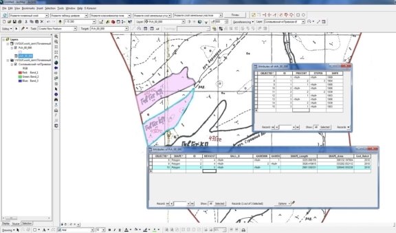
The main stage begins with the process of vectorization of soil contours. This stage begins with the immersion of a soil field map, which was performed during the field period by soil experts and pre-scanned. Next, data is entered into the attribute table for each contour. The introduction of soil data is carried out according to the author's map, as well as a systematic list in the attribute table for each contour (Figure 1)

Fig. 1. Vectorization of soil contours and entering attribute data into tables
Next, you need to check the maps and legends for compliance with the author's material. When errors are detected, corrections are made and the soil map is compiled again through the use of additional program tools.
After making all the necessary adjustments, you can proceed to the design of the map, which includes: conventional signs, symbols, the use of styles, a description of adjacent areas, a scale of coloring according to soil dominants and an angular stamp to the map.
After completing all the previous stages of creating a soil electronic map, they proceed to the final stage. The layout of the map includes the most rational placement of all map elements (symbols, scale, description of adjacencies) for the best readability of the electronic soil map.
The result of all the completed stages is a digital electronic map that allows you to get all the necessary information about the soil resources of this territory.
References:
- Methodological recommendations for the identification of degraded and polluted lands. [Electronic resource] // Electronic Fund: Legal and regulatory and technical documentation. URL: http://docs.cntd.ru/document/902101153.
- On the approval of the Regulations on the Monitoring of Lands of the Republic of Kazakhstan [Electronic resource] // TengriNews. URL: https://tengrinews.kz/zakon/pravi- telstvо _respubliki_kazahstan
- Soil surveys. [Electronic resource] // ВИСХАГИ.URL: http://vishagi23.ru/news/pochvennye-obsledovanija-i-izyskanija.
- Aparin B. F. Soil science. — M.: Academy, 2012. — 272 p.
- Bazdyrev G. I. Agriculture with the basics of soil science and agrochemistry: textbook. for universities. — M.: Colossus, 2009.- 415 p.
- Kazeev K. S. Soil science. Workshop: textbook. manual for academic undergraduate / K. Sh. Kazeev, S. A. Tishchenko, S. I. Kolesnikov. — M.: Yurayt, 2017. — 257 p.
- Law of the Republic of Kazakhstan On Informatization date November 24, 2015 No. 418-VZRK.
- Esri Guide: ArcGIS ebook. Almaty: 2012.


