Sedimentology and geology, which has recently developed in Turkey and in the world, is a science that deals with the morphological structure and development of landforms. In this respect, developing studies with the concept of geomorphosite address and examine the economic, cultural, scientific and visual value of landforms. In this study, it was aimed to examine the sedimentological properties of the sands on the Sarısu-Cebeci coastal coasts of Kocaeli city. Sedimentary rocks, which make up almost 70 percent of the world, are often formations such as ironstone and salt. In this study, it was tried to analyze the formations, geological and sedimentological qualities of the beach sands with a sedimentological point of view.
Keywords: geology, sedimentology, Kocaeli coastal sands, morphology.
1. Introduction
Subject of Research
Approximately 70 percent of the world is covered with sedimentary, that is, “sedimentary” rocks. These are usually, conglomerate, siltstone, sandstone, shale, and, to a lesser extent, salt formations, chert, coal, and ironstone.
The rocks that became sedimentary in geological periods were deposited in environments similar to all the sedimentary environments we see around us today. For this reason, studies carried out in contemporary environments are the most useful tools used to understand the formation of rocks that occurred in geological periods. In addition, some of the different sedimentary rocks present are not found in sedimentary environments that can be observed, explained and interpreted.
Understanding the formation and properties of sedimentary rocks is very important in terms of natural gas and oil that contribute to the economy they contain. For this reason, many petrographic and sedimentological studies are carried out today for the discovery of new coal, oil and mineral deposits. Sodium, petroleum, natural gas, aluminum, coal, salt, gas, construction materials, iron and many different raw materials needed in the world are found in sedimentary rocks. For this reason, the sedimentological properties of the Sarısu and Cebeci beach sands in Kocaeli are examined in this study.
Purpose of the research
The aim is to determine the storage architecture and reveal the natural stone properties by examining the characteristics of Sarısu and Cebeci beach sands in Kocaeli Kandıra region from a geochemical, sedimentary petrographic and sedimentological point of view.
Importance of Research
The research is important in terms of shedding light on other studies to be conducted in the field, since no previous study has been carried out in this area in the city of Kocaeli.
1.2. Geology and Sedimentology Concept
Geology means “examination of the earth” as an English dictionary meaning. Understanding the world should not be treated as something fundamentally easy. This is because the earth has become a “dynamic” mass with a complex and long history, rather than an unchanging sphere of rock (Sainsbury, 2021).
All of these events, such as the destruction and fear caused by an earthquake, the eruption of a volcano in all its glory, the impressive view of the society in a valley on a mountain, the destruction caused by a landslide, are all studied in the field of geology (Jain, 2014). Geology has different sub-disciplines and areas of interest. These are as follows:
Sedimentology or Stratigraphy: This branch of geology deals with how rocks are stored and arranged.
Paleontology: It is the branch of geology that deals with fossil remains from ancient times.
Engineering Geology: The branch of geology that deals with the sensitivity of materials used in buildings.
Petrology: It is a sub-branch of geology that studies the distribution of rocks in the upper mantle and the earth's crust, mineral relationships and chemical compositions (Jain, 2014).
Structural Geology: It is the branch of geology that deals with deformation in rocks.
Hydrogeology: It is the branch of geology that deals with underground spring waters.
Volcanology: It is the branch of geology that studies old and active volcanoes on Earth.
Climatology: It is the branch of geology that deals with climate interactions in the future, past and present.
Mineral Deposits: It is the branch of geology that deals with metallic materials such as gold, chromium, copper and organic materials such as oil, gas and coal.
Geophysics: It is the branch of geology that deals with the internal structure of the Earth (Jain, 2014).
When examined economically, oil is the first to stand out among the 30 most frequently used minerals in the world. Geology is the branch of science that reveals petroleum, which is used as a raw material in the production of more than 10 thousand materials in addition to energy resources in our age, by separating it from the rocks in the earth's crust. In addition to all known resources, different rare earths in the world also constitute many different raw materials offered in our age in terms of humanity (Aslan and Yakup, 2022).
Each type of rock that formed the world basically contains some different information specific to itself. The aforementioned rocks, as metamorphic, contain examples and traces of the metamorphic conditions of the rocks in a certain geography and their changes in space and time. Igneous rocks are filled with some information that is impossible to access directly, reflecting the temperature and pressure conditions and geochemistry of the earth's crust and upper mantle (Vardar, 2018).
The sedimentary rocks, which make up 4/3 of the world in total, also contain information showing their great spread and the earth conditions they have created on the surface. From a different point of view, it provides sedimentary rocks in a much more special position than other rocks in terms of “illuminating the history”, which reveals the main purpose of all geological studies (Nichols, 2009).
1.3. Information about the workspace
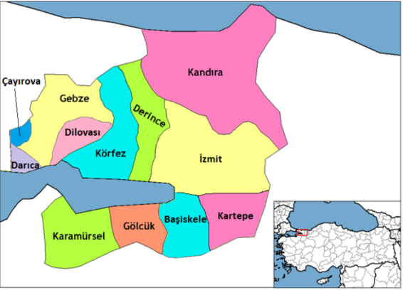
Kocaeli, chosen as the study area, is located in “29° 22' — 31° 22' east longitudes and 40° 31' — 42° 42' north latitudes” in the Marmara Region, as can be seen on Figure 1. Kocaeli has a total area of 3,626 square kilometers.
There are Yalova provinces, Istanbul and Marmara Sea in the west, the Black Sea in the north, Bursa province in the south. According to 2022 data, the population of Kocaeli is 2.033.441 in total (http://www.kocaelismmmo.org.tr/).
Kocaeli's Kandıra region is located on the north side of the city as seen on figure 1. It is the district with the largest surface area of the city with an area of 933 km. A total of 52 kilometers of coast of Kandıra is connected to the Black Sea (Https://Teknolojikkazalar.Org).
The total altitude of Kandıra district is calculated as 75 meters. As a matter of fact, the land in the district has some hills that can be evaluated as small. However, “Çaltepesi 350 meters and Babadağ 400 meters” are hills that can be considered high compared to the district.
There are three important streams flowing into the Black Sea in Kocaeli. These:
— Sarısu Stream
— Seyrek Stream
— Kumcağız Stream (Oktor, 2018).
In addition, “Uzunkum Nature Park” is located in the northeast of the district.
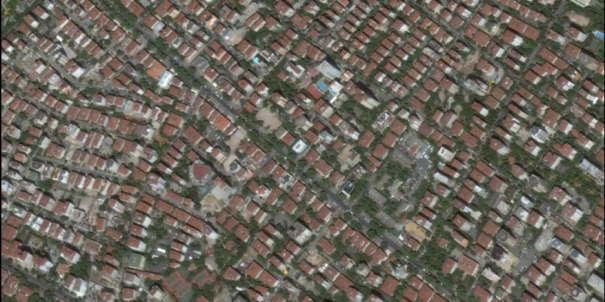
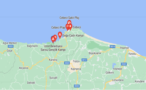
Map and satellite image of the study areas are shown on figures 1 and 2. In addition, the map location image of the study area is shown on figure 3.

Fig. 1. Map view of the Study Area
Source: (http://Www.Kandira.Net/)

Fig. 2. Satellite image of the Study Area
Source: (Https://Teknolojikkazalar.Org)

Fig. 3. Location view of the Study Zones
Source: (https://www.google.com/maps/place/Cebeci+Plaj %C4 %B1/@41.187939,30.250058,16.56z/data=!4m5!3m4!1s0x409e6ddceb7e767b:0xa90cae9eff5b3702!8m2!3d41.1883435!4d30.2511334!5m1!1e4)
Climatic Characteristics of the Study Area
According to the climate group of Kocaeli city, the summers are quite hot and the winters are humid according to the Mediterranean and Erinç climate groups, semi-humid according to the DeMartonne and Thornthowaite climate groups, second degree water deficiency and mesothermal in the summer season, and summers according to the Köppen climate group. It has a climate that is hot, mild in winters and rainy in all seasons (Köse and Özen, 2017).
According to the climate diagram of Kocaeli city prepared according to the data of MGM (General Directorate of Meteorology), average precipitation and average temperature precipitation values, the cold and abundant rainy autumn, winter and spring months, the hot and dry summer months are Kocaeli's “Mediterranean Climate” and “Oceanic” indicates that the climate is at the transition point.
1.4. Geology in Kocaeli Region
There are two different structural and tectonic units in the city of Kocaeli in terms of geology. The first of these is the “Kocaeli Peninsula” located on the northern side of the Gulf of Izmit, which was determined to have emerged from the “Moesian Platform” by Şengör et al. (1983), and which generally includes the Istanbul “Paleozoic” and Kocaeli “Triassic”. The other one is the “Armutlu Peninsula” (MTA, 2005), which is located in the south of the Gulf of Izmit and is a part of the Sakar Zone. The two unions located here are separated from the gulf part of Izmit, one of the provinces of Kocaeli city, by the NAFZ (North Anatolian Fault Zone). They are divided into two as Southern and Northern tectonic units.There are some elevations in Kocaeli in the north and in the Armutlu Peninsula in the south.
Conclusion
In the study, it is seen that the sedimentary rocks that make up 70 percent of the world are generally composed of formations such as coal, iron stone, salt and conglomerate.
However, in addition to these known resources, many rare sands in the world and the elements they contain constitute the raw material of many different products that humanity has actively used.
In this study on the examination of the properties of sands, the city of Kocaeli, which was chosen as the study area, has a surface area of 3.626 km. It is also known that there are three important streams flowing into the Black Sea in Kocaeli city. These creeks are defined as Seyrek Stream, Sarısu Stream and Kumcağız Stream. There are two geologically different tectonic and structural units in the study area. These are Kocaeli Peninsula and Armutlu Peninsula located in the north of Izmit Bay. The coasts of Kandıra and Cebeci, which form the center of the study area, are an important touristic and sedimentologically important area. In the study, the sedimentological properties of these beach sands were examined and the structural materials and the basic components they contain were tried to be determined.
References:
- Aslan, N., & Yakup, Say. (2022) Nadir Toprak Elementlerinin Uygulama Alanları. Kırklareli Üniversitesi Mühendislik ve Fen Bilimleri Dergisi, 8(1), 148–178.
- Http://Www.Kandira.Net/Cebeci-Plaji-Kandira.Html Date of access: 20.11.2022
- https://www.google.com/maps/place/Cebeci+Plaj %C4 %B1/@41.187939,30.250058,16.56z/data=!4m5!3m4!1s0x409e6ddceb7e767b:0xa90cae9eff5b3702!8m2!3d41.1883435!4d30.2511334!5m1!1e4 Date of access: 20.11.2022
- Jain, S. (2014). Fiziksel Jeolojinin Temelleri (S. 129). Springer Hindistan.
- Kocaeli İl Çevre Durum Raporu, 2022 Https://Teknolojikkazalar.Org/Get_File?İd=4d3e67294b619 Date of access: 20.11.2022
- Köse, M., & Özen, F. (2017). Hereke (Kocaeli) Florası. Sakarya Üniversitesi Fen Bilimleri Enstitüsü Dergisi, 21(6), 1165–1175.
- MTA. (2005). Türkiye Jeoloji Haritalar, 1/50.000 Ölçekli, Bursa 22-b ve 23-a Paftaları. Jeoloji Etütleri İdaresi, Ankara.
- Nichols, G. (2009). Sedimentology And Stratigraphy. John Wiley & Sons.
- Oktor, K. (2018). İzmit Körfezine (Kocaeli, Türkiye) Dökülen Derelerde Cr (Vı) Tayini. III. Internatıonal Ratıng Academy Congress On Applıed Scıences.
- Sainsbury, C. L. (2022). Geology And Ore Deposits Of The Central York Mountains, Western Seward Peninsula, Alaska.
- Vardar, S. (2018). Sedimantolojik ve Mikropaleontolojik Verilerle Güzelhisar Çayı Kıyı Ovasının Holosen Paleocoğrafyası. Doğu Coğrafya Dergisi, 23(39), 131–148.


