The North Caspian Maritime Canal with berthing facilities is future construction; it can be called Sea Gate of the Казахстан. With intensive oil production in the North Caspian, area will be used to deliver goods to onshore fields. Safe operation ensuring of such unique and critical engineering structures is achieved by conducting geodetic monitoring.
Keywords: maritime canal, berthing facilities, the Caspian sea, construction, technology, geodetic works, modern equipment, satellite systems.
Северо-Каспийский морской канал с причальными сооружениями является перспективным строительством, его можно назвать Морские ворота Казахстана. При интенсивной добыче нефти на Северном Каспии, объект будет использоваться для доставки грузов на наземные месторождения. Обеспечение безопасной эксплуатации таких уникальных и ответственных инженерных сооружений достигается проведением геодезического мониторинга.
Ключевые слова: морской канал, причальные сооружения, Каспийское море, строительство, методика, геодезические работы, современные приборы, спутниковые системы.
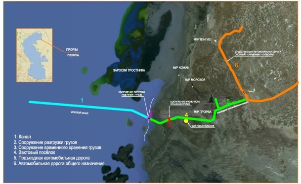
North Caspian Maritime Canal with berthing facilities for goods traffic based on the special Project of “TenizService” LLP currently is under construction. The project provides for the following structures (Fig. 1):
— Maritime canal;
— Turning basin;
— Maritime earth deposit;
— Berthing facilities for discharging cargo (FDC);
— Stockpiling area and catch basin;
— Service road and others
North Caspian Maritime Canal will be used to goods traffic for support of construction operations and oil fields and industrial enterprises in Atyrau and Mangistau regions. The following cargo is expected to be transported [1,2]:
— supply of building materials for road construction and supply of concrete aggregate from Mangistau region seaports (Bautino, Sartas);
— supply of metal products (structural steel, pipes, drill pipes, modules) from Caspian Sea ports (Aktau, Kuryk, Baku, Astrakhan) and from other sources outside the Caspian (through the Volga-Don canal);
— goods delivery by containers (consumables, tools and specialized goods).

Fig. 1. Construction scheme of maritime canal and turning basin
Eastern part of the North Caspian belongs to the Kazakhstan water area of the Caspian Sea and according to administrative division the coast belongs to Atyrau region of the Republic of Kazakhstan. The regional center is Atyrau located over distance 375 km. and administrative center is Kulsary located over distance of 135 km from construction area.
Basis of the district’s road network consists from nation highways: Atyrau-Dosor-Aktobe and Dossor-Kulsary-Beineu-Shetpe-Zhetybai-Mangystau-Aktau seaport.
Last adjoins regional and local significance roads passing through the Tengiz field: Kulsary-Tengiz-Sarykamys-Prorva and Tengiz-Prorva.Currently, total length of public roads is at about 590 km, 72 % of which are hard-surfaced.
In the north of the district section of national highway Atyrau-Aktobe runs parallel to the railway. In geomorphologic terms project area is a flat coastal plain. There is no river system in the territory. The northeastern part of the Caspian Sea adjoined to district is characterized by shallow water. The coastline is indented little, there are small sand spits.
The nearest oil fields under development are: Tengiz field — one of the richest in the world, Western Prorva, Prorva, Kozhan, Morskoye, Aktobe, etc.
All coastal zone is involved flat areas of possible flooding. Tengizchevroil oil deposits and Korolevskoye as well as the EmbaMunayGas oil fields are protected from sea by protective dams, crests of which are at minus 23.5 m BU.
Construction of large technical structural constructions such as dams, canals and high buildings is essential. Safe operation ensuring of unique and critical engineering structures, as well as equipment is achieved through periodic monitoring, which also includes geodetic monitoring. Deformation state monitoring of such structures is one of the application areas of high-precision geodetic methods and measuring instruments. Another important task of high-precision geodetic measurements is determination of equipment geometric parameters which is under installation, operation or reconstruction [3, 4]
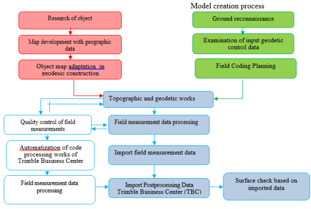
Therefore, safety of these structures requires comprehensive geodetic monitoring using high-precision measuring instruments; general work scope on terrain model building is shown in Fig. 2.

Fig. 2. Geodetic work scope on creation 3D terrain model
Construction of berthing facilities for discharging cargo (FDC) with turning basin was accompanied by huge amount of excavation and geodetic measurements.
In the framework of previously obtained 3D terrain models, scope of earthworks was calculated as accurately as possible according to Branco Etera Ltd. program. Berthing facilities were deformed and required constant monitoring. Since occurrence of GLONASS and GPS, as well as on the basis of continuous process of technology improving of total stations and laser levels, problems of predicting deformations of engineering structures have been solved on qualitatively new basis.
With the use of satellite methods, precision of coordinate definition in combination with speed of obtaining final results is determined by necessity of detail research, as well as the economic possibilities of organizing this type of work. Development of high-performance satellite methods for coordinate definition based on the use of GPS fundamentally changes technology and accuracy of determining geodetic coordinates and principles of constructing geodetic networks, which are actual implementation of coordinate systems.
Construction of large technical structural constructions such as dams, canals and high buildings is essential. Safe operation ensuring of unique and critical engineering structures, as well as equipment is achieved through periodic monitoring, which also includes geodetic monitoring. Deformation state monitoring of such structures is one of the application areas of high-precision geodetic methods and measuring instruments [5, 6].
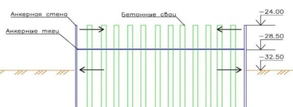
One of the most critical stages of construction is the construction of sheet pile walls forming moorings. The inner side of the quays consists of a 9 m high sheet pile wall. The sheet piles themselves are driven to a depth of 15 m from the ground. The outer walls are made up of 17 meters long sheet piles. After completing the driving of sheet piles at -24.00m, the inner side of the berths is covered with sand followed by tamping, and then two opposite berths are reinforced with anchor rods at -28.00m and the whole structure is again filled with sand followed by tamping to -23.50m. (Fig. 3).

Fig. 3. Observed sheet pile wall
Then there is the process of driving concrete piles between the berths for the foundation of the port structure, the weight of which can exceed several hundred tons — all this leads to deformation of the sheet pile wall. As result, tongues are displaced according to plan and height.
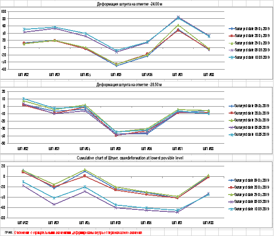
The monitoring results were processed using the Microsoft Excel program and tongue-and-groove deformation diagrams were obtained (Fig.4), where the greatest shifts were observed in the piling sections. For these sections, special groups of tongues were selected [7].

Fig. 4. Deformation diagram of sheet pile wall
According to observations results (2019), it can be argued that the upper and lower measurement areas “blew out” to the outside due to soil pressure, reinforcing concrete piles, and short, middle area was pulled together by anchor rods from the opposite side, on the contrary, shifted inward. Such results over the entire observation period were repeated several times and specific anti-deformation measures were taken.
Conclusions
- Comprehensive analysis of domestic and foreign experience in geodynamic studies on instrumental observations of deformations areas was carried out, which allowed developing methodology for integrated assessment and prediction of hazardous phenomena in GDP.
- The methodology for repeated observations of the GDS points has been improved, including complex geodetic observations: high-precision digital leveling, the use of electronic tacheometers and GPS technologies, which will improve the accuracy and efficiency of determining the subsidence of the earth's surface, as well as the effectiveness of monitoring due to computerization of field and office geodetic works.
- Proposed methodology for geodetic works to ensure hydraulic structures using modern technical means will allow high degree of accuracy to monitor objects condition and develop anti-deformation measures, protection of the subsoil and the environment.
Acknowledgments . Study was financially supported by the Science Committee of the Ministry of Science and Higher Education of the Republic of Kazakhstan (AP14871828).
References:
- The project “Route of goods transportation for objects of the north-eastern part of the Caspian Sea. North Caspian Maritime Canal with mooring facilities. RSE «Gosexpertiza» No. 01–0561 / 15 dated 12/23/2017);
- Nurpeisova M. B., Rysbekov K. B., Kirgizbaeva G. M. Innovative methods of conducting complex monitoring at geodynamic polygons. -Almaty: KazNITIU, 2015.-265 p.
- Nurpeissova M., Kyrgizbaeva G.The Geodetic Monitoring of the Engineering Structures Stability Conditions //Journal of Engineering and Applied Sciences:2017| Volume: 12 Issue: 11 SI Page No.: 9151–9163.
- Nurpeisova M., Bekbassarov Z., Kenesbayeva A., Kartbayeva K.Complex evaluation of geodynamic safety in the development of hydrocarbon reserves deposits // News of the National Academy of Sciences of the Republic of Kazakhstan-Series of Geology and Technical Sciences. 2020. Vol.1. P.90–98. DOI: 10.32014/2020.2518–170X.11
- The project “Route of goods transportation for objects of the north-eastern part of the Caspian Sea. North Caspian Maritime Canal with mooring facilities. RSE «Gosexpertiza» No. 01–0561 / 15 dated 12/23/2017).
- Nurpeisova M., Myngzhassarov B.,Shultz R. Geodetic construction support of the North Caspian Sea channel with berthing facilities// Almaty: Mining journal of Kazakhstan, 2020, № 1.- С.6–10.
- Myngzhassarov B., Shultz R. Geodetic construction support of the sea channel // I Международная научно-практическая конференция «Ways of science development in modern crisis conditions». — Киев. 28–29 мая 2020 г.


