Modern methods of surveying in engineering and hydrographic works | Статья в журнале «Молодой ученый»

Отправьте статью сегодня! Журнал выйдет 30 ноября, печатный экземпляр отправим 4 декабря.

Опубликовать статью в журнале

Авторы: ,

Рубрика: Технические науки

Опубликовано в Молодой учёный №43 (490) октябрь 2023 г.

Дата публикации: 30.10.2023

Статья просмотрена: 18 раз

Библиографическое описание:

Ережеп, Г. Т. Modern methods of surveying in engineering and hydrographic works / Г. Т. Ережеп, С. Т. Солтабаева. — Текст : непосредственный // Молодой ученый. — 2023. — № 43 (490). — С. 15-18. — URL: https://moluch.ru/archive/490/107112/ (дата обращения: 16.11.2024).


The article discusses the conduct of engineering surveys at hydrographic facilities using modern technology and programs.

Keywords: engineering and hydrographic works, aerial photography, UAV, echo sounder, bathymetry.

Engineering surveys are a set of works carried out in order to obtain the information necessary to solve the main problems related to the choice of a cost-effective and technically justified place of construction, design, construction and operation of structures.

Engineering and geodetic surveys provide topographic Geodetic information and local conditions and terrain, including the bottom of the reservoir, reservoir, water body, currently functioning buildings and structures (underground and surface), other planning elements necessary for a comprehensive assessment of the natural and man-made conditions of the construction area (water body) (in digital, graphic, photographic and other forms) and the basis of construction design, operation and decommissioning of the facility, as well as the management of the area, ensure the receipt of data on the state inventory, which ensures the conduct of real estate transactions.

Engineering and Hydrographic works carried out on rivers and lakes, water areas include a complex of survey works that ensure the receipt of data on the water surface (River, reservoirs, lakes, coastal channel), terrain and depth measurements, topographic survey of the coastal part, etc [1].

Engineering and Hydrographic work was carried out along the contour of the water area of Lake Sorkol, located on the territory of the Mugalzhar District of Aktobe region. On the southwestern side of Lake sorkol lies the dry bed of the Kundyzdy River, which is filled with seasonal snow waters. Between the kundyzdy River and Lake Sorkol, there is a canal that fills the lake with water. The contours of the water area are clearly distinguished by vegetation and terrain, as well as aerial survey work was carried out using UAV «Mavic 2 Pro», assembled with a receiver from the satellite navigation system of the company «Topodrone» to accurately determine the contour. Bathymetry of the river bottom was performed using the Lowrance Hook 2–4 X Bullet echo sounder with the Leica GPS GX-1230 receiver in conjunction with the satellite navigation system.

Aerial photography — obtaining a digital model of the Earth's surface by photographing the Earth's surface from above and processing the resulting images in a program [2]. Widely used in the modern market. The main advantages are reduced labor force, the ability to quickly capture a large area in a short time and obtain high-precision information on complex objects, as well as to obtain an orthophotoplane, creating not only a digital model of the Earth's surface. The technical characteristics of the UAV used in the survey work are shown in Table 1.

Table 1

Technical characteristics of the instrument «Mavic 2 Pro»

Weight

0,907 kg

Length/width/height (mm)

242/322/84

Maximum flight range

18 km

Angle of inclination

25º

Maximum flight time

31 min (25 km/hour)

Maximum flight altitude above sea level

6000 m

Aerial photography was carried out to accurately determine the contours of the water area and vegetation cover. In the work on the creation of the orthoplane, the Earth's surface marks determined by a preliminary instrument were used [3].

Currently, one of the main advantages of UAV flights is the ability to create a preliminary flight route with full aerial photography of the working area. The route can be built with many programs. During this work, the program «UgCS for DJI» was used.

First of all, the information received from the UAV was post-processed in special programs. They are:

— Processing of data obtained from the satellite navigation system using the «ToRinex4" program;

— In order to determine the center of photos with maximum accuracy, subsequent processing is carried out in the «TopoSetter» program.

The main processing of aerial photography data was carried out in the program» PIX4Dmapper».
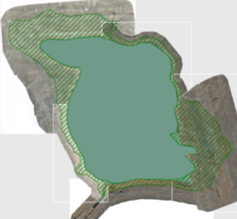
Fig. 1. Orthophotoplan

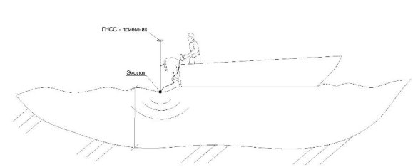
Bathymetry of the river bottom was performed in conjunction with the Lowrance Hook 2–4 X Bullet echo sounder using a Leica GPS GX-1230 receiver. The execution of the work is shown in Figure 2.
Z:\Galiya\Сабақ\Набор блоков AutoCAD_транспорт-Model.jpg

Fig. 2. Execution scheme

Next, the file is uploaded to the AutoCAD Civil 3D program, where three-dimensional models and sections of technological platforms are created. The volume and area of water in the river were clearly calculated. Sections were processed in AutoCAD Civil 3D. The sections are shown in Figure 3.
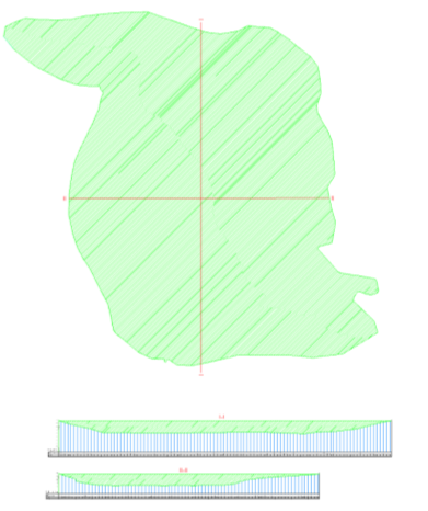
Fig. 3. Sections of Lake Sorkol

Conclusion. As a result of the processing of field and cameral work, we determined the area and water reserves of the Sorkol River. As a result, the area of the river was 3087392.31m 2 , and the volume was 12979951.94m 3 . Using modern shooting methods, the results of the work were made in a short time and with minimal labor.

References:

  1. АО «КазНИИСА». СП РК 1.02–105–2014 Инженерные изыскания для строительства. Основные положения. Астана 2015. Инженерно-гидрографические работы 24 стр.
  2. Thamer Rayes Thiyab The Use of Unmanned Aircraft in Aerial Photography in Engineering Geodesy Journal of Babylon University/Engineering Sciences 2017,25,5 1626–1627.
  3. Yuri Ten1, Olga Schukina? Albina Valieva. Creation of topographic plans using unmanned aerial photography. E3S Web of Conferences 381, 01020 (2023), pp. 3. DOI: https://doi.org/10.1051/e3sconf/202338101020.
Основные термины (генерируются автоматически): UAV, GPS, DJI, DOI.


Ключевые слова

aerial photography, engineering and hydrographic works, UAV, echo sounder, bathymetry

Похожие статьи

The problems of mining ecology

This article is devoted to negative impacts of mining industry to the environment, specifically discussed geological and geometrical features of the mine, affect of chemical elements, technical and technological processes as well.

Conducting lectures and practical classes in medical universities using modern methods

The article provides a brief overview of the use of interactive teaching methods in teaching medical sciences, teaching methods using modern pedagogical technologies that students must learn and apply in specific practical situations.

Ethics of microtransactions

The article discusses the ethics of using microtransactions in the videogame industry.

Improvement of mathematical knowledge of primary school students on the basis of modern technologies

This article analyzes the advantages and disadvantages of the use of modern innovative and advanced foreign experience in mathematics lessons of primary school students. In order to increase the effectiveness of the use of pedagogical technologies in...

The special characteristics of engineering education

In the given article the authors researched the main and special characteristics of developing high engineering education.

Method of assessing energy efficiency in small refrigerating machines

The article presents the results of research on the problem of increasing the energy efficiency of small refrigeration machines. Approaches and algorithms of evaluating the technical condition of these cars are given.

Structural and semantic features of the terms of the oil industry of the English and Turkmen languages

Modelling as method of scientific knowledge of physical processes

The article deals with computer simulation of physical phenomena and processes, which is the most promising direction of using information technologies in physical education.

Casing cementing technology with installed hydromechanical centralizers

The article sets the task to consider the possibility of improving the technology of centering casing strings during well cementing. This is achieved by including hydromechanical centralizers in the casing rigging. The result is an increase in the re...

Modern specificity of the application of GIS methods in Russian archaeology

The article is devoted to the study of the place of geoinformatics methods in the Russian archeology of the modern stage. Characteristic features of the use of GIS have been identified, which determine the specifics of modern complex archaeological r...

Задать вопрос